


NASA plans to use drones to monitor active volcanoes
SOURCE: DIGITALTRENDS.COM
JAN 30, 2022
NASA doesn’t only work on space projects: The agency also takes part in Earth-monitoring projects, particularly those related to the climate. Currently, it is working on a plan to use drones to monitor active volcanoes and give warnings of potential eruptions.
NASA is collaborating with the company Black Swift Technologies, which creates highly rugged drones of unmanned aircraft systems (UASs) which can withstand the tough environments above volcanoes. “We needed it to be really rugged, to withstand flying in the turbulent conditions and corrosive gases around volcanoes,” said Florian Schwandner, director of the Earth Sciences division at NASA Ames in a statement. “We also developed a gas-sensing payload the UAS could carry to look for signs of volcanic unrest.”

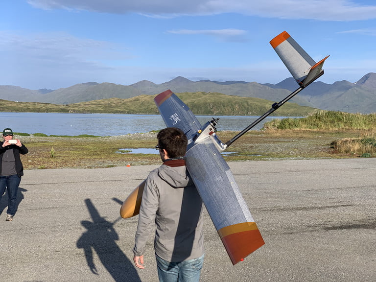
Maciej Stachura of Black Swift Technologies carries the S2 aircraft to its launch site at Dutch Harbor airport in Alaska.Aleutian Aerial/Andy Dietrick
A first version of the UAS was tested for monitoring a volcano in Costa Rica in 2013, and a newer version of the craft has recently been tested with flights at Makushin Volcano in the Aleutian Islands in Alaska. The drone can fly even when it is out of visual range of the pilots, by using autonomous systems combined with a pre-set flight plan to reach the volcano’s summit. From there, it can collect visual and thermal information on volcanic activity.
“Our goal is to continue to push the capabilities of UASs to provide valuable insight into natural phenomena,” said Jack Elston, CEO of Black Swift Technologies. “This deployment demonstrated some state-of-the-art automation technologies we think will help greatly simplify what are now very difficult UAS operations. One of the most exciting results was to see our custom autopilot system determine when conditions had become too dangerous and turn back.”

View of the Makushin Volcano summit captured by a camera on the wing of the S2 aircraft. The unmanned aircraft system flew autonomously beyond range of its pilot’s sight – 15 miles away and to an altitude of 6,000 feet – to capture data about volcanic activity during a flight demonstration in September 2021. Black Swift Technologies
The hope is to develop this technology so that it can routinely monitor volcanoes and act as an early-warning system if an eruption is imminent.
“Working with NASA and Black Swift, our scientists believe we can use UASs to help authorities warn communities about the onset of dangerous volcanic eruptions, and many other hazards that now take us by surprise,” said Jonathan Stock, director of the United States Geological Survey National Innovation Center. “With this tool, we could routinely monitor even remote volcanoes for activity and respond to eruption events — a gamechanger for the safety of both our scientists and the communities around these geologic hazards.”
LATEST NEWS
Artificial Intelligence
Eerily realistic: Microsoft’s new AI model makes images talk, sing
APR 20, 2024
WHAT'S TRENDING

Data Science
5 Imaginative Data Science Projects That Can Make Your Portfolio Stand Out
OCT 05, 2022

Similar articles you can read
Coventry University expert explains what Amazon drone deliveries means for jobs and the price of a package
SOURCE: HTTPS://WWW.COVENTRYTELEGRAPH.NET/
NOV 02, 2023
This New Autonomous Drone for Cops Can Track You in the Dark
SOURCE: HTTPS://WWW.WIRED.COM/
SEP 26, 2023
Tamil Nadu government approves farm mechanisation subsidy for Garuda Aerospace drones
SOURCE: HTTPS://AGRICULTUREPOST.COM/
SEP 25, 2023
The Future Of Biomedical Transport: Drones At The Service Of Health
SOURCE: HTTPS://WWW.EMERGENCY-LIVE.COM/
AUG 25, 2023
Groundbreaking Drone Flights with Radiation Detection Pave the Way for Improved Safety on Nuclear Sites
SOURCE: HTTPS://DRONELIFE.COM/
AUG 11, 2023
Drone with sticky patches studies biodiversity by bumping into trees
SOURCE: HTTPS://WWW.NEWSCIENTIST.COM/
JUL 13, 2023