


Digital twins on the manufacturing menu – with help from the hyperscalers
SOURCE: HTTPS://WWW.IOTTECHNEWS.COM/
NOV 16, 2023
Geospatial infrastructure to address current, future challenges
SOURCE: GEOSPATIALWORLD.NET
OCT 20, 2021
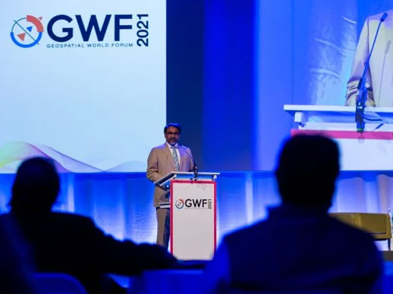
“The world is realizing the value of geospatial technology. We as a community are making a great contribution in Global economy and Growth” said Sanjay Kumar, CEO, Geospatial World at the opening remark of the GWF 2021.
In more ways than one, the global geospatial community felt it has turned over a new leaf at the Geospatial World Forum 2021 in the post COVID-19 pandemic era as it returned to the physical world after a forced hiatus of approximately two years.
Delegates and exhibitors from more than 60 countries have come together to brainstorm and deliberate the way forward in the age of data explosion on one hand and deal with the existential challenges of sustainability and social equity on the other. Thought leaders from the geospatial industry felt that going forward, Geospatial Knowledge Infrastructure will play an increasingly critical role in decision-making, driving efficiency and productivity, and tackle the myriad threats posed by vital issues like climate change.
“We are just beginning to test ourselves again. How we as a global community work towards rebuilding this humanity and this world. Of course, I don’t think we have much choice to keep away from sustainable developments or sustainable economy. We have to get our act together and that’s why the theme of this conference is Geospatial Infrastructure and Digital Twins, and its combined value for circular economy. There are a lot of positives too; the world recognized the value of geospatial information in the description of the situation and modeling of the situation and predicting and prescribing how to deal with the situation,” said Sanjay Kumar, CEO, Founder, and Editor-in-Chief of Geospatial World, in his keynote remark, welcoming the delegates.
“In Zaanstad, we use the Zaan Digital Atlas—a digital repository of all the information at our disposal. It’s a resource for all kinds of geographical information and every employee in Zaanstad can use it. Some of our employees use it on a daily basis,” said Annette Baerveldt, Deputy Mayor of Zaanstad.
The opening session titled “Geospatial Infrastructure and Digital Twin: Empowering Circular Economy” set the tone for the plenary. All the speakers on the panel acknowledged that digitalization is the key to deal with the challenges of the future. Digitalization has become a standard in today’s world. Digital twinning has been at the forefront of exploration and progress.
“We see developments in key areas combined with new technologies and improved skills form a strong foundation for brining digital lives together. Such a twin brings different sets of data together. It visualizes planned situations and provides a common picture. It brings stakeholders together and it’s able to calculate and predict alternative scenarios—smarter, faster, and committed,” said Frank Tierolff, CEO, Kadaster.
Connecting the physical world to the digital is a necessity in today’s complex and interconnected world for improved productivity, better decision-making, and sustainability.
“Today we are excited by the fact that technology is being used to lay the foundations of tomorrow. We are truly transforming the way the world works by optimizing task productivity at the convergence of the physical and digital worlds. We achieve this by our deep roots in positioning and sensing, modeling and analytics. Providing the right combination of collaboration and interoperability to help users worldwide make intelligent decisions, serve complex problems, and improved operating results on safety,” said Olivier Casabianca, Vice-President, GeoInstruments, Trimble.
With the pace of change becoming faster in an interconnected world, time is of the essence, as pointed out by Dean Angelides, Corporate Director, International, Esri. And for that science and technology are humankind’s two best allies. “We have to change our priorities and we need to shift those very quickly and we need to begin action now. This really means to apply our best science, our best technology, and bring what got us to this point, that is, human creativity and not just the digital representation of that. To do this, geography and geographic thinking are essential, which we call as the geographic approach. It’s a way of thinking and problem solving, and it integrates geographic science and information of all types. It helps create understanding and it’s that understanding that precedes action. This geographic approach is holistic, it’s science-based, it’s collaborative and it allows us to do geo-accounting,” said Angelides.
“Integration is, of course, one of the powerful elements of geospatial information. As we saw, there are these layers of information that we can put together on a geographical basis. I think, working with that integration element is very powerful to address the problems that we face. One of the things that is happening right now is we are pushing from data and information to knowledge and the next step is, obviously, from knowledge to action,” said Stefan Schweinfest, Director, Statistics Division, United Nations.
He further emphasized on the need to build National Geospatial Knowledge Infrastructure to deal with the problems of the world and find better solutions. “We want to build a global geospatial knowledge infrastructure. We have developed global networks and integrated geospatial framework that is not only a language through which we can talk across countries, but it’s also a capacity building and development tool and helps us over time consistency of information,” said Schweinfest.
In the second session of the morning titled “Space and Geospatial Value Chain—Co-creating Geospatial Knowledge Infrastructure”, the panelists highlighted the role of geospatial technologies in aiding recovery post-Covid, bridging the digital divide, and building capacities in lower and middle-income countries that don’t have access to cutting-edge technologies. Reinhard Blasi, Acting Head of Communications, EUSPA (EU Agency for the Space Programme), pointed out that the mandate of the agency is to bring the services down to earth to help is the management, operation, improvement evolution, and protection of infrastructure apart from being the gatekeeper of security of critical infrastructure and help in market development and innovation.
Yana Gevorgyan, Director, GEO Secretariat, elaborated on the need for cross-border collaboration in Earth Observation for a more equitable global development. “We in GEO firmly believe that Earth Observations have no borders, and we need a coalition of the willing governments and partners, who would come together and take a similar approach of transboundary, transdisciplinary and trans-sectoral to work collectively, to mobilize action to bring Earth Observation to the forefront of decision making,” said Gevorgyan.
LATEST NEWS
WHAT'S TRENDING
Data Science
5 Imaginative Data Science Projects That Can Make Your Portfolio Stand Out
OCT 05, 2022

SOURCE: HTTPS://WWW.IOTTECHNEWS.COM/
NOV 16, 2023
SOURCE: HTTPS://AITHORITY.COM/
OCT 03, 2023
SOURCE: HTTPS://WWW.SCIENCEDAILY.COM/
AUG 08, 2023
SOURCE: HTTPS://WWW.GLOBALLOGIC.COM
JUL 06, 2023
SOURCE: HTTPS://INDIAAI.GOV.IN/ARTICLE/HOW-DIGITAL-TWIN-TECHNOLOGY-WILL-EVOLVE-IN-2023
JUL 04, 2023
SOURCE: HTTPS://WWW.CNBC.COM/2023/01/21/DIGITAL-TWINS-ARE-SET-FOR-RAPID-ADOPTION-IN-2023.HTML
JUN 30, 2023